Tuesday, May 31, 2011

Hutcheson Cemetery believed to be one of the oldest in Baxter County

This very old family cemetery is located on the left (South) side of Baxter CR 108 near the "Steamboat Shoals" area of the White River. From Push Mountain Road, take Baxter CR 108 about 3 miles. The cemetery is just before a private road (Serenity Ln.) on the left on property now owned by Mr. and Mrs. Wilson, who I have had the pleasure of meeting and speaking with. Due to the previous extreme overgrown conditions, the cemetery would not have been noticeable when driving past, except that there is an old cemetery sign that is affixed to the top of a cedar post. There are only 3 graves identified with engraved markers in this cemetery, but it's very obvious from walking through the cemetery that many others are buried here. A few graves are marked with field stones.  There is one unmarked stone cairn along the roadside. The other gravestones are located about 20 yards in from the road.

According to Dolan Acklin, a noted writer and local historian who lives in the area, this cemetery may have been in use as early as 1847.  I had the pleasure of visiting with Dolan and with Bob Bounds on the day the cemetery was being cleaned up.  They told me how they hunted for and found this lost cemetery many, many years ago in the thick brush and vines.  They found that about half of the pieces of the stone cairn had been scraped away and scattered by a road grader.  They gathered the cut limestone blocks and reconstructed the cairn.   The cemetery had not been cared for or maintained at all in recent years, and it was cleaned up by county jail inmates in January, 2011.    It is now being kept weed-eated by the jail inmates.


                                         Hutcheson Cemetery sign, Summer 2009

                                         Hutcheson Cemetery - overgrown condition

                                         Cemetery clean up underway by jail inmates

                                         The three headstones are found in the thick brush

                                          The stone cairn along the roadway at the
                                           cemetery boundary

                                          Bob Bounds and Dolan Acklin near the end of
                                          the cemetery clean up

                                          New sign mounted for Hutcheson Cemetery,
                                          but the old sign was left in place as well.

Monday, May 30, 2011

Goodall Cemetery was rescued from many years of neglect

The Goodall Cemetery is located directly behind the former Countrywood Realty building (now Peglar Real Estate Group) at 1327 Highway 62 East in Mountain Home. The small cemetery is enclosed by a chain link fence. For many years it was completely overgrown and neglected, but someone  has now cleaned it up and re-set the headstones, some of which were down. According to Roger Talburt, Mr. Bob Durr from Mountain Home is the person who cleaned up this little cemetery and is caring for it.  There are at least eight (8) known burials by name in this old cemetery. The burials date from 1854 to 1890 and are from the Goodall, Duty, Foster, Richey, and Talbert families.


                                           The fence at the Goodall Cemetery before
                                            it was cleaned up.

                                           Peeking over the fence before clean up, the
                                           cemetery was an abandoned derelict.

                                           The cemetery as it appears after clean up.  All
                                           the headstones have been re-set.

                                           Goodall Cemetery overview photo, after clean up.
 

A new sign was made and placed on the
fence in February, 2013 by Jail Inmates at
the Baxter County Sheriff's Office.


An old cemetery some call the "Norman-Rorie Cemetery" lies in a field East of Big Flat

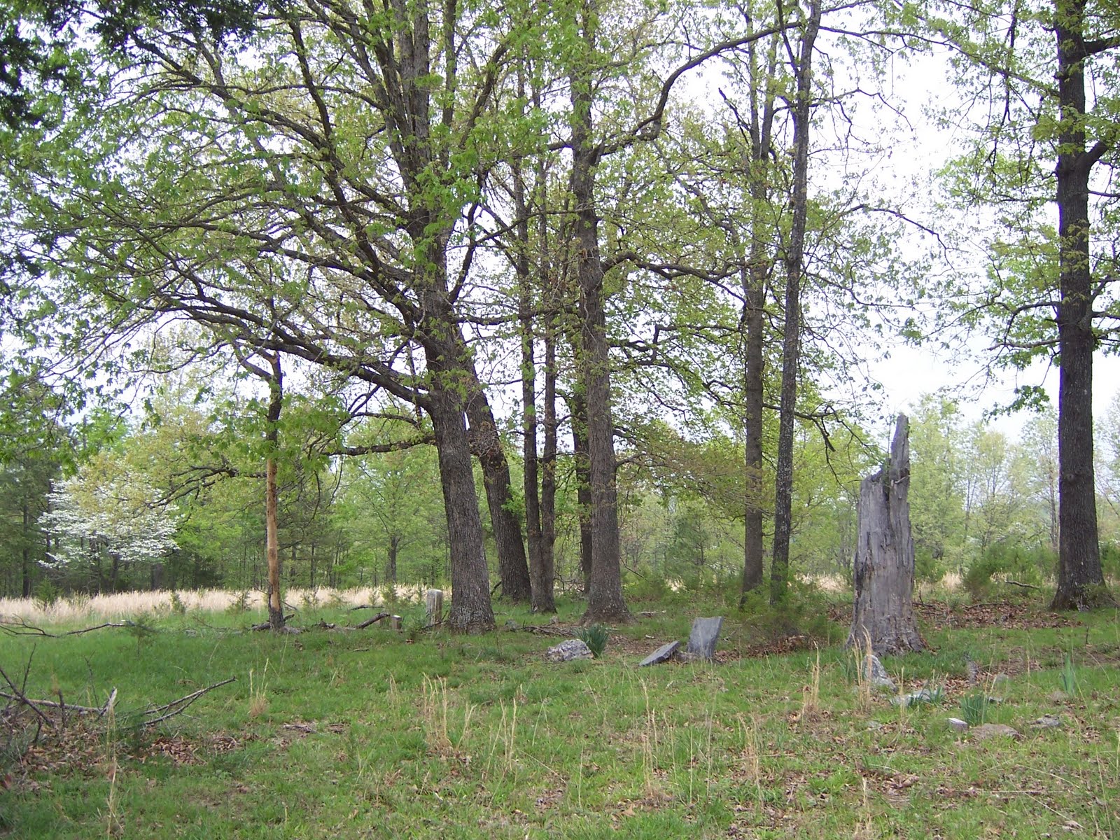
The remains of an old cemetery are located in a field on private property off Baxter CR 116 in the Big Flat area. The cemetery is referred to in one source as the "Norman-Rorie Cemetery", but is not listed by that name in any other known sources or references. It is not mentioned at all in the Baxter County Cemetery Book.  Access to the cemetery is limited to walking West off CR 116 from a metal gate, down a tree line for about 100 yards, then South over a fence into another field. The cemetery is abandoned, grown up, and uncared for. There are a couple of upright field stones barely visible through the brush, but little evidence of it remains. There is a barbed-wire fence (apx 40 ft x 40 ft) surrounding the cemetery, with a gate on the South side. Several local area residents have been asked for history or background on this cemetery. A few of them were familiar with its existence, but only one could offer any information about it.   A gentleman who owns the adjoining property told me that the cemetery dates from the Civil War era. He says there are about 12 to 15 graves there, including members of the Rorie family.

Note:  In August, 2011 a Mr. Kenneth Rorie confirmed there are several members of the Rorie family buried here, as well as members of the Norman family who married into the Rorie family.  The cemetery is on the old Rorie farm.  He says there is only one marked grave, and that it is for one of the Normans. 

                                         Gate at the Norman-Rorie Cemetery

                                          Looking inside the fenced area

Update:  03/13/2013.   Although this family cemetery is located in Baxter County, it is also listed in the Stone County Cemetery Book as the "Old Rorie Cemetery".  According to that publication, the following persons are known to be buried here:

Norman __________
Absalom Rorie, 1798 to 1864
Hezekiah Columbus Rorie, 1822 to 1862
Hugh Frank Rorie, Nov. 19, 1876 to 1908
Louisa A. (Ticer) Rorie, 1822 to 1822
Sarah Jane (Meador) Rorie, 1801 to 1857

Martin Springs Cemetery is in the woods in front of the Martin Springs School/Community Building

This cemetery is located on Baxter CR 108 (Martin Springs Road) off Push Mountain Road. Take CR 108 about 1 1/2 miles to the old Martin Springs School/Community Center on the left. The cemetery is located in the wooded area immediately in front of the church, slightly to the left, but cannot be seen from the church. You have to walk into the woods to see it.  The graves are of twins William E. and Hattie M. Tucker, born 1884. The graves are surrounded by a rock wall. This tiny cemetery should not be confused with the Martin Cemetery located on Push Mountain Road just South of the Sheid Bridge over the White River, which has also been called the Martin Springs Cemetery in the past.

Update:  Sometime during 2012, the wooded area around this little cemetery was somewhat cleared out.  You can now see the cemetery while driving down CR 108, and it is easier to walk up to now.

                                          The Martin Springs Cemetery - Winter 2009

                                          The headstone at Martin Springs Cemetery


The wooded area around this little cemetery
was somewhat cleared out during 2012, and the
cemetery is now visible from CR 108.


                                         The old Martin Springs School/Community Building

What remains of the Messick-Young Cemetery is at the Meadowsprings Apartment Complex in Mountain Home

The remnants of the Messick-Young Cemetery are located on the Meadow Springs Apartment Complex at the North end of Church Street in the City of Mountain Home. The only remaining marked grave is that of James M. Messick (1842-1902). According to the Baxter County Cemetery book, there are at least 13 graves here by name from the Messick, Hargrave, Parks, and Young families, dating from the mid to late 1800's, with the most recent burial having taken place in 1915. It is believed that many other persons are buried here as well. Some of the graves may now be covered by areas of the apartment complex.

                                          This is all that remains of the Messick-Young Cemetery

                                         A marker identifies the Messick-Young Cemetery

The only remaining marked grave is that of James M. Messick, a Civil War veteran.  This gravestone was set in place on or about October 14, 1992 by three of his great-grandsons, Jack Messick, Perry Jo Messick, and Leon Messick.  James Messick had enlisted at Yellville in July, 1861.  He was wounded at Corinth, Mississippi by a mini-ball in the chest, was furloughed home, and returned to fighting, only to be captured at Port Hudson, Louisiana in July, 1863.  This cemetery is located on what was once the Messick family's homestead and farm. (Info gathered from an article that appeared in The Baxter Bulletin on October 15, 1992.)
                                         

Friday, May 27, 2011

Anderson Cemetery sits isolated in remote location in Clarkridge area

In a Baxter Bulletin news article concerning the cemeteries of Baxter County, circa 2002, there was very brief mention of an "Anderson Cemetery", with the only description being that it was located somewhere in a pasture in Clarkridge. I had never seen any reference to a cemetery by this name or in this location in any other known sources or reference material that was readily available to me. On August 17, 2010, Constable Gary Arwood and a member of the Clarkridge Volunteer Fire Department were able to locate the Anderson Cemetery in response to my inquiry about it. It was found in a wooded area (not today a pasture as previously described) on private property to the East of Ware Rd, which is a gated private roadway in the Clarkridge Area. The cemetery was said to be in very overgrown condition, with downed tree limbs and thick overgrowth making full access on foot very difficult. One identifiable headstone marker was found for Paul Anderson (1891-1927), as well as some other grave sites marked only with field stones. The cemetery is surrounded by a wire fence with a gate at the Southwest corner. Photographs were taken of the cemetery on September 3, 2010 with permission of and escort by Carrie DeFoor, whose grandfather and family now own the property.

UPDATE:  This overgrown cemetery was cleared and cleaned-up by Baxter County Jail Inmates on July 19, 2013 at request of Evelyn Denton, who has relatives buried here.  She plans to place replacement markers with names and dates on additional known gravesites.


                                           The entrance to the Anderson Cemetery

                                           The gravestone for Paul Anderson

                                          An unidentified grave marked with a field stone

Anderson Cemetery following clean-up by
Baxter County Jail Inmates - July 19, 2013.


The Lawson Cemetery is on private property in the Hopewell Hollow community

The Lawson Cemetery is located on private property owned by Roger Pitchford. Access is by Hopewell Hollow Road (Baxter CR 65) to the East of Jordan Road in Southern Baxter County. There is a private driveway turning to the South just before you reach the intersection of Fish Pond Lane. There is no general access to the public. The cemetery is in a field quite some distance North of the private driveway.  All burials are members of the Lawson and King Families. There are only four marked graves, but family members believe that several others are also buried there. The last burial was in 1926.

Linda Bradbury and her husband were kind enough to drive me to the cemetery late one afternoon so I could visit and photograph it. 


                                          The Lawson Cemetery

                                          Another view of the cemetery

                                          Lawson Cemetery - Hopewell Hollow Community

Wake Cemetery serves the Hand Cove community

The Wake Cemetery is located at the intersection of Baxter CR 91 (Hand Cove Road) and Diamond Bay Road. This is a relatively small, active, and well maintained cemetery. The earliest known burials by name originate from the late 1800's, but it is probable that there are earlier burials here as well that are marked only with field stones. There is an old church on the grounds that is now used only for yearly meetings on decoration day, which is the first Sunday of May each year.  The church used to serve as the one room school house for the Hand community.  People gather for a pot luck lunch, decorate the graves, visit and catch up with one another.  There is a Board of Trustees that oversees the Wake Cemetery.  The church itself was in relatively poor condition, but it did receive a new roof in 2009 or 2010 and new paint inside and out in 2013.   The cemetery served the nearby community of "Hand", which ceased to exist when the Norfork Lake filled following construction of the Norfork Dam in the 1940's. The church was moved to its present location before the lake filled.


A crowd gathers for the Wake Cemetery Decoration
on May 6, 2012. 

The Wake Cemetery was alternately known as the "Union Hill Cemetery" at some time in the past. Today, it is always called Wake Cemetery.


                                           Wake Cemetery on Hand Cove Road

                                            Wake Cemetery in May, 2009

                                           Decorated graves at Wake Cemetery

                                           Ladies making preparations for pot luck lunch
                                           on Decoration Day in May, 2010.

                                           The church at Wake Cemetery, before
                                           the new roof was put on. 
 
Wake Cemetery from the air

Sale Family Cemetery is the resting place of the founders of Salesville

The small Sale Family Cemetery is located at the edge of the wood line, across a field to the South of Schwartz Rd/Deer Path Ln in Salesville. There is no direct access by vehicle. You have to park and walk across the overgrown field to the edge of the woods. The cemetery contains only 4 or 5 graves.  According to the Baxter County Cemetery Book, the graves include those of "Uncle Johnny" and "Aunt Peggy", the founders of Salesville. The cemetery is identified by a sign that is posted to a tree. The sign can be seen from the roadway if you are watching carefully, but it is very easily missed.  The approximate coordinates are:   92.27600W, 36.23917N.

                                           The Sale Family Cemetery is in the wood line

                                           Sign for the Sale Family Cemetery

                                          Graves at the Sale Family Cemetery

Reed's Grove Cemetery is just Northwest of Mountain Home

The Reed’s Grove Cemetery is located on Baxter CR 26 (Cannie Baker Road) Northwest of Mountain Home. Take State Highway 5 North from Mountain Home. Turn right on Baxter CR 27 (Walker Rd) by Roller Funeral Home. Follow CR 27 about 1 mile to the Baxter CR 26 intersection. CR 27 turns sharply to the right, but continue straight ahead approximately 1/2 mile further on Baxter CR 26. The small cemetery will be set back off the roadway on the right. There was no sign until recently, and it is easy to miss the dirt turn off. This must be considered an active cemetery, as there are recent burials from the Pittaway family, but the cemetery was mowed and maintained only on an irregular basis, particularly the older section.  The cemetery is now being mowed by Baxter County Jail Inmates on a regular basis.  The cemetery dates from the late 1800's. There are several members of the Reed family buried here, which is probably from where the cemetery gets its name.  On some maps it is referred to as the Baker Cemetery, and there are members from the Baker family buried here, but local sources indicate it has never been called that.

                                           Reed's Grove Cemetery had been neglected and
                                           allowed to grow up

                                          Another view of the unkempt cemetery

                                          A new sign was placed after the cemetery was
                                          cleaned up.  It is now being kept regularly mowed.

                                         Decorated graves from Memorial weekend, 2011

Nelson Cemetery can be found on Baxter CR 1075 in the Buford area

Nelson Cemetery is a family cemetery dating from the late 1800's. It is located on Baxter CR 1075 off CR 57 in the Buford area. The cemetery is on the West side of CR 1075 less than 1/4 mile from the CR 57 intersection. Within the past 10 years or so, someone (probably surviving family) erected a white vinyl fence along the East side of the cemetery facing CR 1075. There is also a sign nailed to a large tree. The cemetery had been completely abandoned with no care for several years. It has since been cleaned up by county jail inmates. There are five (5) known burials by name listed in the Baxter County Cemetery book. Only two or three gravestones remain, one standing upright and the others broken into pieces and lying on the top of a cairn. The engraving on those stones is eroded and fading away. There also are several other grave sites here marked by field stones and other cairns.

                                           Nelson Cemetery as it appear in Winter, 2009

                                          An example of the cemetery overgrowth

                                          A gravestone is barely discernible through the
                                          weeds and brush

                                           Jail Inmates take a break after clean up has been
                                           completed - Winter 2010-11

                                          The Nelson Cemetery after clean up.  It has been
                                          kept mowed and weed-eated since then.

Wednesday, May 25, 2011

Hurst Cemetery sits on a ridge above Martin Springs Road

The Hurst Family Cemetery is found in a remote location that is accessible from Baxter CR 108 (Martin Springs Road), south of Norfork, Arkansas. Travel South on Push Mountain Road from State Highway 201 S. Cross the Sheid Bridge on White River. Continue to the top of the hill, and Baxter CR 108 will be on the left (East) side of Push Mountain Road. It is clearly marked with road signs. Take CR 108 about 3 miles. You will cross over a creek four (4) times, but may not realize it, as there are low water bridges and culverts in place at a couple of those crossings. Immediately after the fourth crossing, which is past Serenity Ln., there will be an unmarked and unnamed dirt/gravel road in poor condition that takes off to the right and goes up a steep hill. A four wheel drive vehicle with good clearance is needed to drive up this road. Even then, you may only be able to drive a certain distance and then have to continue on foot. I had read somewhere that the cemetery was right at the top of this hill. It is not. Once you reach the top of the hill, you must continue several hundred yards further to reach the cemetery. The gravel road turns into an overgrown grass/dirt trail. Keep going, even though you think you may have already passed the cemetery and not seen it. The cemetery will be plainly visible on the right in a small clearing. There are 9 graves marked by commercial headstones of the Hurst family. It is possible that there are 2 or 3 other unmarked graves in this small cemetery. The cemetery may also be accessible from Baxter CR 123 leading in from the opposite direction. Baxter CR 123 runs North from CR 73 (Culp Road), which is several miles further South on Push Mountain Road. The condition of Baxter CR 123 leading to the cemetery is not currently known (August, 2010), and it is not known if vehicular access to the Hurst Cemetery is now possible from Baxter CR 123.

                                         The Hurst Family Cemetery

                                         Example of gravestone monuments in the cemetery

                                         The poor roadway leading to the Hurst Cemetery